Introduction:

Drone technology, coupled with Light Detection and Ranging (LiDAR) technology and advanced image processing software, has revolutionized land mapping and surveying practices. This case study explores how the combination of LiDAR, drones, and image processing software enables efficient and accurate land mapping, providing valuable insights for various industries and applications.

LiDAR Data Collection:

LiDAR technology involves emitting laser pulses from an aircraft or drone and measuring the time it takes for the laser to return after hitting the ground. This data collection method creates highly detailed 3D point clouds, capturing the terrain, buildings, vegetation, and other features of the land surface. LiDAR data collection can be performed using specialized airborne LiDAR systems or integrated LiDAR sensors on drones.

Drone Imagery:

Drones equipped with high-resolution cameras capture aerial imagery of the land surface. These images, along with the LiDAR data, provide valuable visual information for land mapping and analysis. Drones offer flexibility in capturing images from different angles and altitudes, allowing for comprehensive coverage and detailed mapping of the land area.

Data Integration and Processing:

The LiDAR point clouds and drone imagery are integrated and processed using advanced image processing software. This software utilizes algorithms to align and combine the LiDAR and image data, creating accurate and detailed land maps. The software can perform tasks such as feature extraction, terrain modeling, vegetation analysis, and identification of structures or objects of interest.

Mapping and Analysis:

The integrated LiDAR and drone imagery data, processed through the software, enable precise mapping and analysis of the land area. The resulting land maps provide detailed information about elevation, contours, vegetation density, structures, and other features. This data is invaluable for various applications, including urban planning, infrastructure development, environmental assessment, agriculture, and natural resource management.

Benefits and Impact:

1. Accuracy and Precision: The combination of LiDAR and drone imagery, along with advanced image processing software, delivers highly accurate and precise land maps. This level of detail allows for informed decision-making in various industries, reducing errors, minimizing risks, and enhancing project outcomes.

2. Time and Cost Efficiency: Drone image processing, combined with LiDAR technology, significantly reduces the time and cost required for land mapping and surveying. Traditional methods often involve manual field surveys and data collection, which can be time-consuming and expensive. With drones and LiDAR, large land areas can be efficiently surveyed in a shorter timeframe, reducing costs and increasing project efficiency.

3. Enhanced Data Visualization: The integration of LiDAR and drone imagery data enables the creation of visually appealing and interactive land maps. These maps can be viewed in 2D or 3D formats, allowing stakeholders to visualize and understand the land features and characteristics more effectively. This aids in communication, analysis, and decision-making processes.


4. Improved Planning and Design: Detailed land maps derived from LiDAR and drone imagery support better planning and design of infrastructure projects. The accurate elevation data, terrain modeling, and identification of structures help engineers, architects, and urban planners make informed decisions about building placement, road design, drainage systems, and environmental considerations.


5. Environmental Monitoring and Conservation: LiDAR and drone-based land mapping facilitate environmental monitoring and conservation efforts. The data captured can be used to assess vegetation health, monitor changes in land cover, detect forest encroachments, and identify areas of ecological importance. This information supports effective land management practices and contributes to biodiversity conservation.


6. Safety and Risk Assessment: The use of drones and LiDAR technology minimizes the need for personnel to be physically present in hazardous or inaccessible areas. This improves safety during data collection and allows for the assessment of potential risks and hazards. The high-resolution land maps generated through drone image processing and LiDAR analysis provide valuable information for identifying areas prone to landslides, flood risks, or other geohazards. This enables proactive risk assessment and appropriate mitigation measures to ensure the safety of communities and infrastructure.


7. Agricultural Applications: Drone image processing and LiDAR technology have significant applications in agriculture. The detailed land maps can help farmers monitor crop health, assess soil conditions, and optimize irrigation and fertilizer application. By identifying areas of nutrient deficiency or pest infestations, farmers can implement targeted interventions, leading to improved crop yields and resource management.


8. Land Use Planning and Development: The accurate land maps derived from drone image processing and LiDAR data support land use planning and development initiatives. Urban planners and policymakers can utilize this information to make informed decisions about zoning, infrastructure development, and land allocation. It aids in optimizing land utilization, promoting sustainable growth, and minimizing environmental impact.


9. Natural Resource Management: The integration of LiDAR and drone imagery data facilitates effective management of natural resources. Forestry departments can monitor forest cover, assess tree height, and estimate biomass using these technologies. This information assists in forest management, carbon sequestration initiatives, and conservation efforts.


10. Research and Innovation: The combination of drone image processing, LiDAR technology, and advanced software opens up new opportunities for research and innovation. Researchers can explore novel applications, develop new algorithms for data analysis, and contribute to the advancement of land mapping techniques. This promotes continuous improvement in the accuracy, efficiency, and usability of land mapping practices
.

Conclusion:

Drone image processing, LiDAR technology, and advanced image processing software have transformed land mapping practices. The integration of these technologies enables accurate, detailed, and efficient mapping of land areas for various applications. From urban planning and infrastructure development to environmental monitoring and agricultural management, the benefits and impacts of this combined approach are far-reaching. The use of drones and LiDAR technology in land mapping not only improves data accuracy and precision but also enhances safety, reduces costs, and supports sustainable development. As these technologies continue to evolve, they hold immense potential for further advancements in land mapping, research, and innovation.

Point Cloud Image Processing:

Point cloud processing involves the manipulation, analysis, and visualization of large sets of 3D point cloud data. To effectively process and extract valuable information from point clouds, several software tools and platforms are commonly used. Here are some of the key software applications required for point cloud processing:

LiDAR Data Collection:

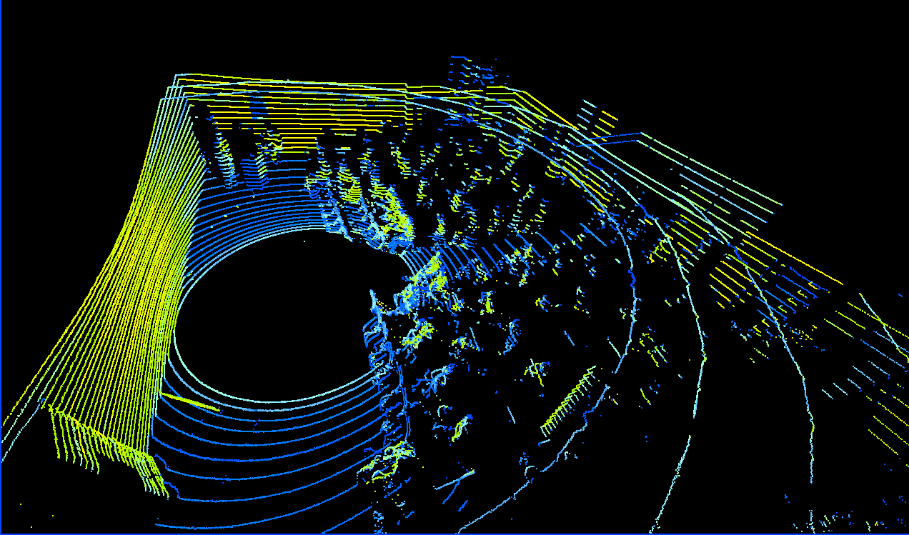
1. LiDAR Software Packages:
TerraScan: TerraScan is a popular software developed specifically for LiDAR data processing. It offers functionalities for point cloud classification, filtering, editing, and feature extraction. TerraScan is widely used in industries such as surveying, forestry, and engineering.
LAStools: LAStools is a comprehensive suite of software tools for LiDAR data processing. It includes modules for filtering, classification, triangulation, and visualization of point clouds. LAStools is known for its efficiency and scalability, making it suitable for handling large-scale point cloud datasets.

2. Point Cloud Processing Software:
Autodesk ReCap: Autodesk ReCap is a widely used software for processing point clouds captured from terrestrial or aerial LiDAR systems. It offers tools for registration, point cloud cleanup, measurement extraction, and mesh creation. ReCap integrates seamlessly with other Autodesk software, facilitating workflows in industries such as construction and architecture.

3. Geographic Information System (GIS) Software:
Esri ArcGIS: ArcGIS is a comprehensive GIS platform that includes tools for handling and analyzing point cloud data. It provides capabilities for integrating point clouds with other spatial data, performing spatial analysis, and generating derived products such as digital elevation models (DEMs) and orthophotos.

4. Photogrammetry Software:
Pix4D: Pix4D is a leading photogrammetry software that can process both images and point clouds obtained from drone or aerial surveys. It enables the creation of highly accurate 3D models, orthomosaics, and point cloud visualizations. Pix4D offers advanced features for point cloud classification, editing, and export to various formats.
Agisoft Metashape: Agisoft Metashape (formerly known as Agisoft PhotoScan) is another popular photogrammetry software used for processing point clouds. It supports dense point cloud generation from aerial or terrestrial images and offers tools for point cloud filtering, classification, and mesh generation.

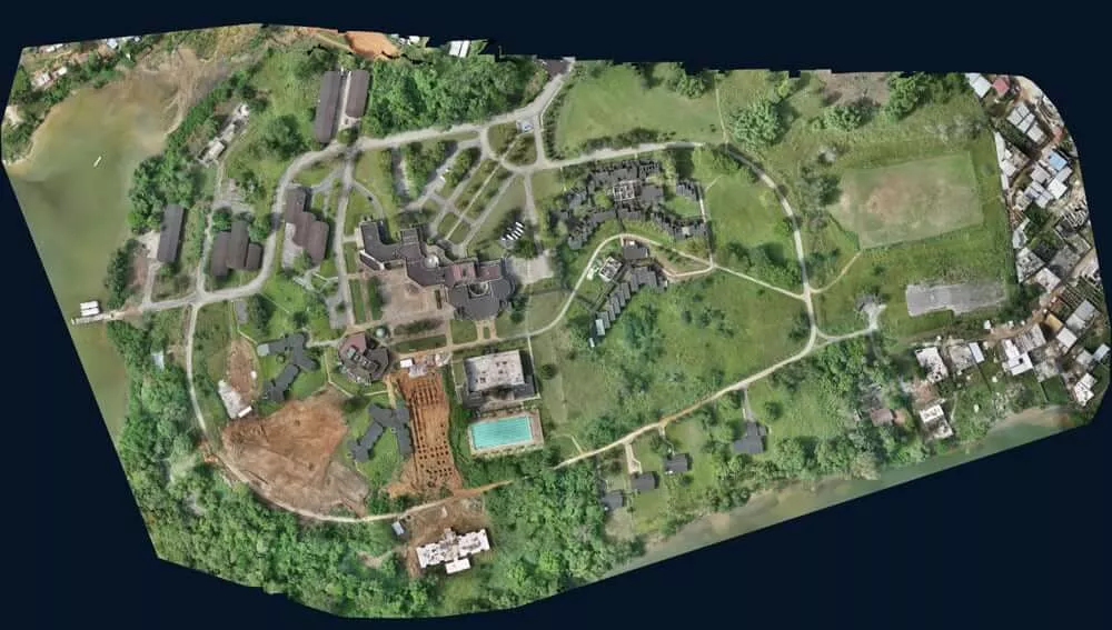
These are just a few examples of software applications commonly used for point cloud processing. The selection of software depends on the specific requirements, complexity of the data, and desired outputs. It's important to consider factors such as data format compatibility, processing capabilities, ease of use, and integration with other software or workflows when choosing the appropriate software for point cloud processing tasks.

The use of drones and LiDAR in the Swamitva initiative has transformed the way surveying is conducted in populated areas, particularly in rural villages. Swamitva is a government program in India aimed at providing villagers with property ownership rights by mapping and surveying their land parcels. Drones and LiDAR technology play a crucial role in this process, offering several advantages over traditional surveying methods. Here is an overview of how drones and LiDAR are utilized in the Swamitva initiative:

1. Aerial Surveys: Drones equipped with high-resolution cameras are deployed to capture aerial imagery of the villages and their surrounding areas. These drones fly over the villages in a systematic pattern, capturing images from different angles and altitudes. The aerial surveys provide a comprehensive view of the land parcels and enable the creation of detailed maps.

2. LiDAR Data Collection: In addition to aerial imagery, LiDAR sensors are used to collect highly accurate 3D point cloud data. LiDAR-equipped drones emit laser pulses that bounce off the ground and surrounding structures, measuring the time it takes for the signals to return. This data is used to create precise elevation models and capture the 3D characteristics of the land surface, including buildings and vegetation.

3. Data Integration and Processing: The captured aerial imagery and LiDAR point cloud data are processed using specialized software. The software aligns and integrates the imagery and LiDAR data, enabling the creation of comprehensive and accurate land maps. This integration allows for the visualization and analysis of the land parcels, buildings, and other features in a 3D environment.

4. Parcel Boundary Identification: The processed data is used to delineate the boundaries of individual land parcels within the villages. Using the high-resolution imagery and LiDAR data, surveyors can accurately identify and demarcate the boundaries of each property. This ensures that the property ownership rights are assigned correctly and disputes over land boundaries are minimized.

5. Property Documentation: The surveyed data is further utilized to create official property documents, including property maps and ownership certificates. These documents provide legal recognition and ownership rights to the villagers. The accuracy and detail provided by the drone imagery and LiDAR data contribute to the reliability and authenticity of these documents.

6. Efficient and Cost-Effective Surveying: The use of drones and LiDAR technology in the Swamitva initiative offers significant time and cost savings compared to traditional surveying methods. Drones can cover large areas quickly and collect data with high accuracy, eliminating the need for manual measurements on the ground. This streamlined process expedites the surveying process and reduces costs associated with manpower and equipment.

7. Minimized Disruption: Traditional land surveying methods often require physical access to private properties, which can be disruptive to the daily lives of villagers. Drones and LiDAR technology minimize this disruption by conducting surveys from the air. The non-intrusive nature of aerial surveys ensures minimal disturbance to villagers while still providing accurate and reliable data.

The use of drones and LiDAR in the Swamitva initiative has revolutionized the surveying process in populated areas. It enables efficient data collection, accurate boundary identification, and streamlined property documentation. By leveraging these advanced technologies, the Swamitva program aims to provide villagers with secure property rights, boost economic development, and resolve land-related disputes in rural India.

Contact Us

Registered Office : E-13, Diya Park Hanuvat Kheda, Ladpura , Kota , Rajasthan -324004
Corporate Office : WZ-243, 1st Floor, Street No.3, Virender Nagar, New Delhi -110058
email: amit.malik@falconinfo.net